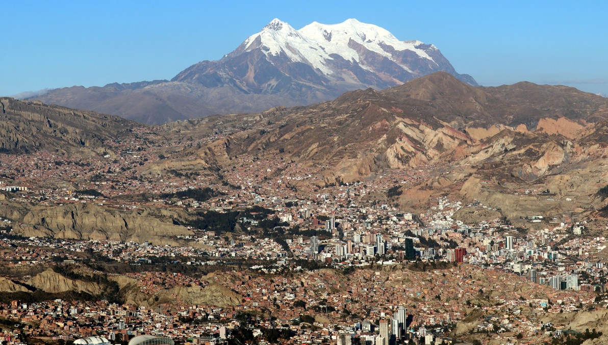
LA PAZ, BOLIVIA
La Paz is the highest country capital in the world (noting that Sucre remains the constitutional capital and La Paz is the executive functional center). The city hides in a deep eroded canyon at the western base of the glaciated Cordillera Real. The city has an inverted social-stratification with the richer neighborhoods being located farther down the canyon, and the poorest sectors clinging to the canyon walls and now spread out across the broad inhospitable plainland to the west and northwest. This high plateau is also where the El Alto International Airport is located, making it the highest international airport in the world. Packed into the canyon and crowded around the plains, 1.9 million people are housed in mostly unfinished brick buildings making the most fantastic and dreadful example of zero building codes.
Viva la revolución! From the independence of Bolivia in 1825 from Spain, the country has had 190 coup d’états, giving it the world record for overthrown governments. Since 1950, there has been 23 coups. Since the National Revolution of 1952, when much of the country also had foreign-owned business interests, including mining, were all nationalized, the country was led by military dictators up to the early 1980s. After democratic model took hold in 1982 under President Hernán Siles Zuazo, the country has followed popularist socialism with communist overtones, with the net result of Bolivia long being considered the poorest nation in South America until the downfall of Venezuela. Nonetheless, by 1985, inflation was out of control, with monthly inflation rates reaching 60% in September 1985, leading to an annual inflation rate of approximately 24,000% for that year. Indigenous groups and labor unions (teachers, farmers, miners, and transportation groups) keep constant pressure on any sitting government for essentially welfare politics and subsidiaries. Today, Bolivia is run by a uniparty called MAS (Movement for Socialism), with strong communist tendencies, an anti-America dialogue (annoyed by the CIA in South America and the US anti-cocaine efforts), and political alignment of the nation with Russia and China. Of course, any pretense at socialism is thoroughly flawed by the pervasive government corruption. Last year in 2024 there was what was likely a staged-coup against President Arce to bolster his abysmal popularity in the country. In 2024, the country carried a national debt of 24.17 billion dollars, while its debt-GDP ratio is at 80.8%, far lower than the USA or Japan, the country lacks debt creation capacity, and combined with subsidizations, the last 7 months the nation has been under perpetual fuel shortages for gasoline and diesel. 2025 is an election year, nobody knows the direction the country will take next. La Paz means the peace. Perhaps the name was given more in hopes versus actual outcomes.
La Paz retains some Colonial Spanish charming building in the city center, and many of the Indigenous women (known as “Cholas) still wear traditional dress, with the wide layered skirts and felt bowler’s hats. The city center is very commercial with many crowded markets filled with packed small booths, making for an unusual experience for those not familiar with South American shopping.

Doing
Plaza de Armas- Plaza Murillo, the heart of the Bolivian government, with the presidential palace along the east side of the square. A relatively small plaza de armas by South America standards, due to the scarcity of flat ground in the La Paz canyon. The Plaza is at an elevation of 3,365 meters, just three blocks north and uphill from the main artery street of Avenida Mariscal de Santa Cruz. As mentioned in the introduction, Bolivia has a tumultuous history of government overthrows, including deaths in the plaza of President Isidoro Belzu (1865), President Agustín Morales (1872), and President Gualberto Villarroel (1946). The name Murillo comes from the revolutionary Pedro Domingo Murillo (1757-1810) who was hanged in the plaza before Bolivia achieved its independence. To this day, the plaza is a focal point for social conflicts, with the government frequently posting police and military for crowd control and occasionally shutting off access to the plaza for several blocks around the presidential palace.
Museo Nacional de Arte is in a historic building on the southwest corner of Plaza Murillo. Its collection is mainly that of old Catholic church oil paintings and some modern Indigenous work focused on injustice.

Museo Nacional de Etnografía y Folklore (MUSEF), located on Ingavi 916 with cross street of Genaro Sanjeni, lies two blocks west from the northwest corner of Plaza Murillo. They have an impressive collection of traditional carnival masks.
Calle Jaén– is a narrow street with attractive historic businesses and small shops and restaurants tucked away, making a retreat from the greater city of La Paz. Just a five block walk uphill from Plaza Murrillo (follow Inavi west for three blocks, turn right onto Pinchincha and go uphill one block, turn left onto Indaburo then go one block to the start of Calle Jaén). Calle Jaén is only one block long, so it does not take much time for a visit.
Museo San Francisco– this a tour of the convent and part of the 18th century church called Basílica Menor Nuestra Señora de los Ángeles. In the bell tower, they have a model of what the Colonial town of La Paz started like. This historic building is probably one of the more important sights to see in the city.
Calle de Brujas – the Witches Street, lies along four blocks of the street called Linares, which is two blocks uphill to the south from the San Francisco church. It has more tourist shops selling alpaca sweats, blankets, and ponchos than witches with their wares- the farther west side of the narrow street has a few supporting shops for Andean pagan rituals- including incense, herbs, small idols, and dehydrated llama fetuses. These are serious beliefs held by the highland Indigenous groups of Aymara and Quechua speaking communities, which is mostly centered around Pachamama, and catchall Mother Earth plus attendant evil spirits. The coca leaf is held in high esteem in all the ceremonial offerings, commonly called “mesas” or “challas” where bottles of cheap alcohol, coca, cigarettes, and other knickknacks are placed in the make-shift shrines spread out on blankets on the ground. The dehydrated llama babies are burned, whereas grander events require the sacrifice of live full-grown llamas. Four-hundred and eighty years of Catholic missionaries and churches in every town yield only partial conversion and mixing of Andean beliefs with Christian doctrines. Explore the shops, but keep in mind many of the local women are very averse to having their pictures taken. But if you buy something from them, they will likely share some stories giving a small glimpse into Bolivian traditions.


Teleféricos
La Paz can be explored in a rather unique way for a major city- by riding the network of gondolas (if you are not afraid of heights). With ten lines, each with a separate color, and several different stations to exchange lines, you will have remarkable, if not frightening, views of the brick labyrinthine clinging to the cliffsides. From city center, running down the main axis of the canyon to the upscale Calacoto, take the sky-blue and green lines. The stations at the valley rim in El Alto have spectacular views over the city- these can be reached by the purple and yellow lines. The “Mi Teleférico” includes:
Green (Línea Verde) Calacoto (station Irpawi) to Miraflores (Libertador)
Sky Blue (Línea Celeste) La Paz center (station Prado) to Miraflores (Libertador)
Orange (Línea Naranja) La Paz (center station) to Villa Pabon (Heroes)
Red (Línea Roja) La Paz (center station) to El Alto (16 de Julio)
Yellow (Línea Amarilla) Sopocachi (Libertador) up to El Alto (Mirador)
White (Línea Blanca) Miraflores (Arce) to the Busch Monument (Heroes)
Purple (Línea Morada) La Paz (station San Jose) and El Alto (Faro Murrillo)
Brown (Línea Café) Las Villas to Pampahasi
Silver (Línea Plateada) El Alto area (stations 16 de Julio to Mirador)
Blue (Línea Azul) El Alto area (16 de Julio to Rio Seco)
It is possible to transit a rough circle around La Paz by taking the city center the sky-blue, yellow, silver, red, orange, white, then back on sky-blue lines (expect this to take several hours to half a day).
The first gondola line was completed in 2014 and there area plans to add an additional line to be called the dorada (golden). The La Paz cable car system have been built by the Doppelmayr Garaventa Group, an Austrian-Swiss company renowned for its expertise in ropeway engineering, and this network is the largest one in the world. The combined line total to 30.6 kilometers (19 miles). Many of the station names and Spanish signs also are labelled in the Aymara language.

Staying
La Paz has an abundance of cheaper hostels- we don’t stay in those (rather not worry about items being stolen from the room while out exploring the city).
Hotel Europa, City Centre, Tiahuanaco 64, is closer to the old center, about a nine block walk to the plaza de armas. The hotel is one block northeast of the main road of Avenida 16 de Julio, and just north of the traffic circle of Plaza de Estudiante. This is a tall building, somewhat dated, but with spacious rooms. The hotel restaurant is okayish, it could be better, but many of the dining options in the immediate area of the hotel are not very worthwhile either. The rooftop bar, if open, provides interesting views of the city at night.
Casa Grande, street C. 16 8009, is located well down the valley in the barrio called Calacoto, is a new venue more favored by business travelers. The advantage of this hotel is proximity of the better dining in La Paz, the downside is it is a longer drive to the airport, and it is too far to walk to the plaza de armas. The hotel lies one block east of the bosque group of restaurants. The hotel restaurant offers good quality, but a somewhat limited menu.
Dining
City center area: immediate downhill from the Museo San Francisco, for a good view, try the rooftop dining at Ichuri Coffee – Restaurant. At the eastern end of the Calle de Brujas (Linears), the expat magnet is the English Pub, pub food with Bolivian beer. Overall, we have always found the dining in the historic center underwhelming.
Calacoto area: in the bosque area, see La Casa del Camba, and two blocks up to the east, the restaurant El Salar for steaks.
Montenegro area (several blocks east of Calacoto): the Italian restaurant Fellini, on Calle Rene, Gabriel René Moreno 1383, is mainly open for the evening. Paladar-Cozinha Brasileira, a Brazil steakhouse, located on Avenida Montenegro #858 at the corner with the street Pancara.
Trips in the region
Three nearby halfday to full day trips in the mountain bike ride down the Death Road, a visit to the pre-Incan ruins of Tiwanaku, and the short trip to walk around Valle de Luna.
Do connect with us:
ResearchGate: James M. Wise
Author´s page: James M. Wise
Photography page: JamesM.Wise.com
Author´s page: Yanira K. Wise
Exploring South America’s inexhaustible creative force.

