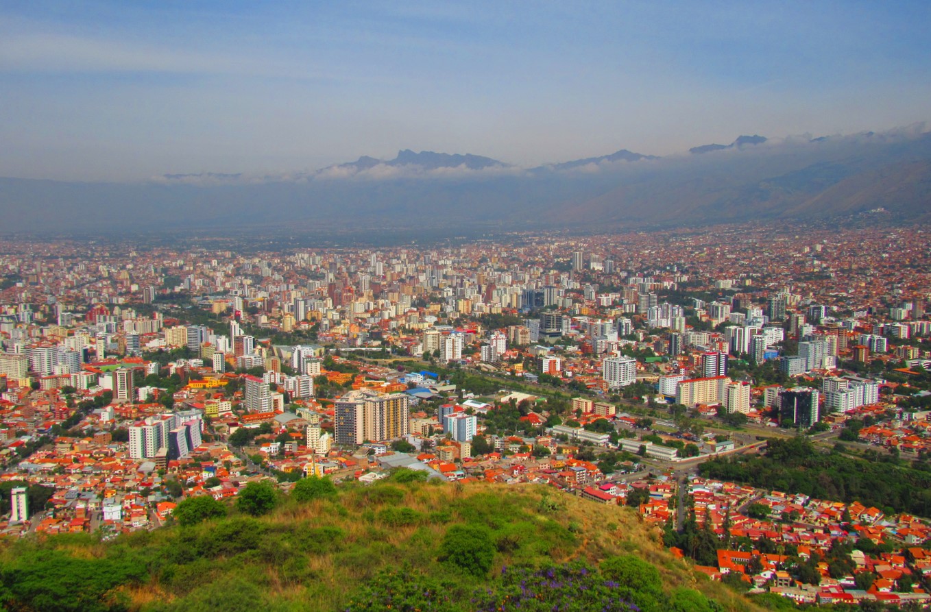
COCHABAMBA, BOLIVIA
Bolivia’s third largest city of Cochabamba (population ~1.35 million) fills the alluvial fan lined crescent-shaped valley at the base of the Cordillera Real. The valley runs about 44 km east-west, 15-km north-south, and lies at an elevation going from 2,600 m in the west up to 2,700 meters in the east. The highest peak in the overshadowing mountains is Tunari, at about 5,035 m elevation (also listed as 5,023m). It can be accessed by driving up the canyon along Morchata Road to the east of the peak and passing around its northern side to a trailhead located to the south of Laguna Toro.
Cochabamba makes a residential area for temperate climate known for being warmer than La Paz (and with more oxygen) and cooler (and less humid) than Santa Cruz. The city continues to grow in a sprawl of at least twenty barrios, but do not look for any international flights to travel into Bolivia through this city.
The drive between Cochabamba to La Paz takes seven and half hours along Route 4 connecting to Route 1. From the city to Santa Cruz de la Sierra is a nine-hour drive along Route 4. The Jorge Wilstermann Airport is located southwest of downtown, about a 10-to-15-minute taxi ride. While the airport is reasonably modern the national airline BOA check-in can be a crowded unorganized affair, the security gate equal with confusion, and once inside to the gates there are few services to pass the time or have some food if you get caught in an 8-hour flight delay like we had.
In the Andean Quechua language, “cocha” is the word for lake, and “bamba” is a place. Thus, Cochabamba is the place of the lake. The namesake doesn’t fit that well, it is more an elongate alluvial plain that is now covered in a gridwork of paved and dirt roads.

Staying
With over sixty hotel and hostel options, we are not going to provide a complete review of these options but rather point out the higher-end business-oriented venue Gran Hotel Cochabamba as safe and clean place to stay. It is located on the north side of the Recoleta oval and has several dining options within walking distance.

Dining
Many Bolivians consider Cochabamba as having the best food in the country. A classic Bolivian dish is called Pique a lo Macho– consisting of a big serving of stir-fried steak, chorizo, sometimes chicken, and hot dog mixed with French fries. In addition, another favorite is the Salteña, which is more for breakfast, but it is basically an empanada filled with beef stew. Another typical dish is the breaded steak dish called Silpancho that is usually served with a fried egg. Also give a try of the Chorizo Chuquisaqueño or pork dish of Ranga and enjoyed with the hot sauce called Llajua.
Some longer lived traditional dining can be found at Casa de Campo (just east of the Recoleta oval) and La Cantanata (one block west of Plazuela Colon along Mayor Rocha street). More upscale modern steak dining see Kansas Bar and Grill (Trinidad street west of Recoleta oval).
Doing
A recommended start to exploring Cochabamba is to first visit the city “mirador.” East of downtown is a prominent hilltop with great overlook accessed by a long twisty road going up to a parking lot, and the Cristo de la Concordia towering statue. At the base of the hill road entrance, they cover a small fee. A short ascent of stairs brings one to the summit terraces, which has a restaurant called Patrimonio Restaurante Cochabamba.
Plaza de Armas (Plaza Metropolitana 14 de Septiembre), which is the focus for exploring any Latin America city or town, offers a couple of coffee shops. The immediate blocks around the plaza are more commercial stores, which include some bookshops. Most of the southern side of plaza has the Metropolitan Cathedral Basilica of St. Sebastian, its entrance is at the southeast corner of the square.
Three and half blocks north of the plaza, it is worthwhile taking the one-hour guided tour of the Santa Teresa Convent (entrance located along C. Baptista Street). The convent was constructed in 1760 and includes a church that has an unusual thick curving outer wall design that was never completed to plan. The life of seclusion and prayer is explained on the tour while visiting several rooms that have examples of religious artwork and period furniture.

One block south of the Plaza de Armas lies the Museo Arqueológico de la Universidad along the street Nataniel Aguirre. It opens at 8:30 am and takes about an hour to visit while reading all the display literature explaining the ceramic pots, weavings, arrowheads, and even several mummies.
The north side of Rio Rocha, to the north of the plaza de armas, has the more upscale residential part of the city. Between this and plaza, many restaurants can be found along Avenida Jose Ballivian, which connects into the Plazuela Colon. Another route, Avenida Salamanca, goes northeast six blocks to the traffic oval and parque at Plaza Quintanilla. Back north of Rio Rocha, on the south side of Queru Queru barrio, the Blvd de la Recoleta pedestrian way makes a center for nightlife.

Do connect with us:
ResearchGate: James M. Wise
Author´s page: James M. Wise
Photography page: JamesM.Wise.com
Author´s page: Yanira K. Wise
Exploring South America’s inexhaustible creative force.


